Visitors, quarrying and Romans
- By: Guy Hunt |
- Apr 28, 2008
- Share
- del.icio.us

There have been quite a few good developments on site since I last added to the journal. Last week was a very busy week with lots of new finds and lots of visitors to the site. I must say, my site tour and introduction speech is getting pretty polished now.
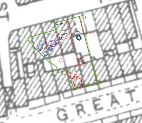
GIS screen shot showing the post medieval buildings over the 1894 OS map.
In the southern half of zone 1 we reduced the overburden down to the level of the post medieval buildings. We cleaned these off and recorded them with the total station which is a really quick and efficient way to survey this kind of archaeology. These buildings date to the first half of the 18th century and we found a lot of the internal features of the buildings. It was really nice to see the survey data laid out over the historic mapping and to see how the finds from the trench match up with the overall urban layout. These buildings also make rather photogenic remains.
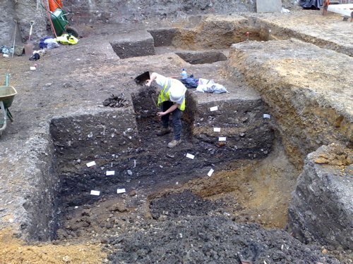
Ashley digging a 1m sample from the fills of the big quarry pit
In the northern half of the site, Anies has been supervising the reduction of a huge block of intercutting pits and Ashley has been supervising a really huge feature that was originally known as “the blob” but is now better known as “the quarry”. I mentioned this in my last journal entry, but we seem to be getting to grips with this a lot better now. This feature is a huge quarry pit with straight vertical sides at least 2m deep and 5m wide. Initially, it was the sheer size of the feature that confused us, but by methodical excavation Ashley seems to have cracked it now. The quarry was first encountered in trench 1 of our evaluation. Back in 2006 we put our evaluation trench right into the centre of the quarry which you could say was lucky or unlucky depending on your point of view. This is the feature which contained really good preservation of leather and organic materials including the shoes. As these shoes date to around 1480, we have got a pretty good idea of when the pit started to be backfilled. The fills themselves seem to be a big mix of domestic rubbish. The question of what the gravel was used for, where the rubbish came from and so on remain to be answered.
This whole area of zone 1 seems to have been subject to quite intensive quarrying activity, both from the huge quarry and from the series of large pits in Anies’s area. We have a linear feature which is probably a ditch that we think at the moment may represent a property boundary and it seems to be the case that the quarrying activity is located west of this linear feature. At the moment this is really just a hypothesis, so watch this space.
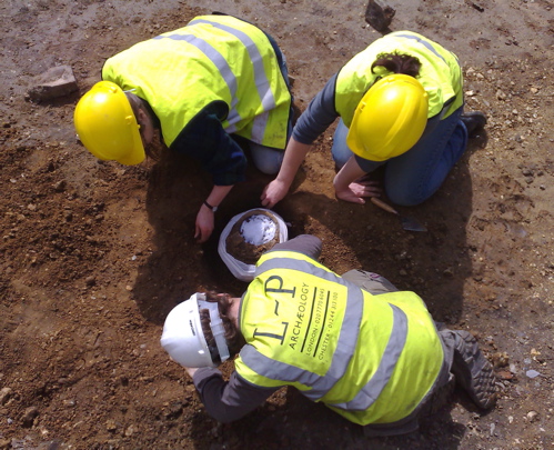
Liz, Nancy and Greg lifting the first cremation urn.
One exciting piece of work last week was the lifting of the first cremation from the site. Liz Goodman a specialist conservator came down from the Museum of London to help us lift the cremation urn without breaking it. Anies got some good footage of the work so we will hopefully get that edited up into a short film soon. The urn itself was complete and had a lid covering the contents. The ashes looked to be in pristine condition inside so it will be interesting to hear back from the lab when they have taken the contents out.
Last week’s visitors included a site visit from English Heritage who make regular monitoring visits to make sure that our work is being done to the right standard and to discuss issues of strategy. David Divers is the English Heritage advisor for the London Borough of Tower Hamlets and he came down for his monitoring visit with Jen Heathcote the Regional Science advisor. Along with Mike Allen our own archaeological environmental specialist, we discussed some important issues about the way we are going to sample features for environmental archaeology -definition evidence and in particular we discussed how we would sample the big quarry pit. Another really useful thing was that during tea break Mike Allen gave a “toolbox talk” to the diggers about good on site sampling practice.